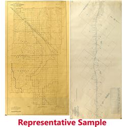
 3238 - Southern Pacific RR Maps of Mojave to Owenyo
Holabird Western Americana Collections
Approximately 12, 2' x 5' blueprint on paper maps of the SPRR route from Mojave to Owenyo (near Lone Pine). The maps are labeled in the titl...
Bidding Has ConcludedEstimate : 300.00 - 900.00
Sold to G********B.. for (150.00 + 36.00BP) = 186.00
Details...Bookmark
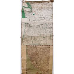 3240 - Maps of California, Nevada, Washington, and Oregon
Holabird Western Americana Collections
Indexed Maps of California, Nevada, Washington, and Oregon gives Counties, County Seats, Railroads, Seaports, Elevations and Stage Routes. Paper maps
Bidding Has ConcludedEstimate : 150.00 - 250.00
Sold to u********y.. for (40.00 + 8.40BP) = 48.40
Details...Bookmark
 3241 - Map of Northern California and Nevada
Holabird Western Americana Collections
Railroad and County Map of Northern California and Nevada. Framed, 17.25" x 25.25". State:California / Nevada City: Date: ID#43836
Bidding Has ConcludedEstimate : 120.00 - 250.00
Sold to B********R for (60.00 + 14.40BP) = 74.40
Details...Bookmark
 3242 - Four Colorado Early Maps
Holabird Western Americana Collections
1) Colorado, Nebraska, Kansas and Dakotah map. 12.5 x 16". Drawn and Engraved by WH gamble. 1865. Nice condition. 2) Clason's railroad Map...
Bidding Has ConcludedEstimate : 100.00 - 150.00
Sold to m********1 for (150.00 + 36.00BP) = 186.00
Details...Bookmark
 3243 - Two Colorado Railroad Maps
Holabird Western Americana Collections
1) Clason's Railroad map of the route between Denver to Fort Collins and Colorado Springs. 28 x 8.5". Pristine Condition. 2) Atlantic-Paci...
Bidding Has ConcludedEstimate : 300.00 - 500.00
Sold to b***5 for (150.00 + 36.00BP) = 186.00
Details...Bookmark
 3244 - Three Early Colorado Maps
Holabird Western Americana Collections
Colorado Drainage Map. 1873. Geological Survey. By Hayden. 19 x 23". Heavy folds, but not tears or small holes! Fabulous condition. The area ar...
Bidding Has ConcludedStart Price : 100.00 | Estimate : 200.00 - 400.00
Details...Bookmark
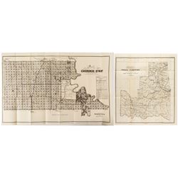 3245 - Two Indian Territory Maps
Holabird Western Americana Collections
1) Map of the Cherokee Strip. September 8, 1893. U. S. Survey by EW Wiggins. Great Rock Island Railroad ad. Rock Island and Santa Fe shown of map. Sho
Bidding Has ConcludedEstimate : 150.00 - 250.00
Sold to i*********1 for (150.00 + 36.00BP) = 186.00
Details...Bookmark
 3246 - Two Pocket Maps
Holabird Western Americana Collections
1) Rand McNally Pocket Map for Louisiana, 1912. 2) Hammond's Guide Map of New Orleans. State:Louisiana City: Date: ID#44132
Bidding Has ConcludedEstimate : 100.00 - 150.00
Sold to d******a for (55.00 + 11.55BP) = 66.55
Details...Bookmark
 3247 - Official Map of Goldfield
Holabird Western Americana Collections
Official Map of Goldfield and South Goldfield Federal Townsites, 1909. Surveyed by James H. Parks, U. S. Mineral Surveyer. State:Nevada City:Goldf
Bidding Has ConcludedEstimate : 100.00 - 400.00
Sold to 6*****b for (250.00 + 50.00BP) = 300.00
Details...Bookmark
 3249 - Map of the Territory of New Mexico
Holabird Western Americana Collections
Includes a list of Mining Districts. Red lines indicate springs, running water, and irrigation districts. Form the Secretary of the interior. 21 x 1...
Bidding Has ConcludedEstimate : 100.00 - 200.00
Sold to i*********1 for (60.00 + 14.40BP) = 74.40
Details...Bookmark
 3250 - Two Washington Territory Maps
Holabird Western Americana Collections
1) 1883 General Land Office Map. NC McFarland, Commissioner and GP Strum draughtsman. Colored. 30 x 24." No rips of tears at folds. A few minor...
Bidding Has ConcludedEstimate : 200.00 - 400.00
Sold to g***s for (190.00 + 45.60BP) = 235.60
Details...Bookmark
 3251 - 3 Land Settlement/Sale Documents
Holabird Western Americana Collections
1) State of Nebraska, Compliments of the Guaranty Investment Company, No. 19 Broadway, New York, 1888. 2) Map of Crawford, Cherokee, Labette, Neosho,
Bidding Has ConcludedEstimate : 200.00 - 400.00
Sold to n**********4 for (110.00 + 26.40BP) = 136.40
Details...Bookmark
 3252 - Two Rand-McNally Pocket Maps
Holabird Western Americana Collections
1) The Rand McNally Pocket Map of Kansas, 1911. 2) The Rand McNally Pocket Map of Illinois, 1912. Both in good condition, fold-out maps intact. State
Bidding Has ConcludedEstimate : 100.00 - 200.00
Sold to i*********1 for (35.00 + 8.40BP) = 43.40
Details...Bookmark
 3253 - Confederate Oath of Alliance
Holabird Western Americana Collections
James P Parker swore his oath of allegiance to the United State of America on June 19, 1865 at Fort Delaware. This seems to be James Parker, Lieutenan
Bidding Has ConcludedEstimate : 100.00 - 300.00
Sold to i*********1 for (225.00 + 54.00BP) = 279.00
Details...Bookmark
 3255 - Black Hills Daily Pioneer Newspaper
Holabird Western Americana Collections
Volume 3, Number 16. It is mounted so we can't see the inside. There is, however, an article on Led City on the front page. State:Dakotas Ci...
Bidding Has ConcludedEstimate : 50.00 - 75.00
Sold to b********0.. for (25.00 + 6.00BP) = 31.00
Details...Bookmark
 3256 - News of Titanic
Holabird Western Americana Collections
Two newspapers with articles of the Titanic. One is German--"Die Ahendschule", May, 1912. and "Current Events", Chicago--"T...
Bidding Has ConcludedEstimate : 70.00 - 120.00
Sold to d******0 for (70.00 + 16.80BP) = 86.80
Details...Bookmark