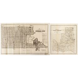
 3245 - Two Indian Territory Maps
Holabird Western Americana Collections
1) Map of the Cherokee Strip. September 8, 1893. U. S. Survey by EW Wiggins. Great Rock Island Railroad ad. Rock Island and Santa Fe shown of map. Sho
Bidding Has ConcludedEstimate : 150.00 - 250.00
Sold to i*********1 for (150.00 + 36.00BP) = 186.00
Details...Bookmark
 3246 - Two Pocket Maps
Holabird Western Americana Collections
1) Rand McNally Pocket Map for Louisiana, 1912. 2) Hammond's Guide Map of New Orleans. State:Louisiana City: Date: ID#44132
Bidding Has ConcludedEstimate : 100.00 - 150.00
Sold to d******a for (55.00 + 11.55BP) = 66.55
Details...Bookmark
 3247 - Official Map of Goldfield
Holabird Western Americana Collections
Official Map of Goldfield and South Goldfield Federal Townsites, 1909. Surveyed by James H. Parks, U. S. Mineral Surveyer. State:Nevada City:Goldf
Bidding Has ConcludedEstimate : 100.00 - 400.00
Sold to 6*****b for (250.00 + 50.00BP) = 300.00
Details...Bookmark
 3249 - Map of the Territory of New Mexico
Holabird Western Americana Collections
Includes a list of Mining Districts. Red lines indicate springs, running water, and irrigation districts. Form the Secretary of the interior. 21 x 1...
Bidding Has ConcludedEstimate : 100.00 - 200.00
Sold to i*********1 for (60.00 + 14.40BP) = 74.40
Details...Bookmark
 3250 - Two Washington Territory Maps
Holabird Western Americana Collections
1) 1883 General Land Office Map. NC McFarland, Commissioner and GP Strum draughtsman. Colored. 30 x 24." No rips of tears at folds. A few minor...
Bidding Has ConcludedEstimate : 200.00 - 400.00
Sold to g***s for (190.00 + 45.60BP) = 235.60
Details...Bookmark
 3251 - 3 Land Settlement/Sale Documents
Holabird Western Americana Collections
1) State of Nebraska, Compliments of the Guaranty Investment Company, No. 19 Broadway, New York, 1888. 2) Map of Crawford, Cherokee, Labette, Neosho,
Bidding Has ConcludedEstimate : 200.00 - 400.00
Sold to n**********4 for (110.00 + 26.40BP) = 136.40
Details...Bookmark
 3252 - Two Rand-McNally Pocket Maps
Holabird Western Americana Collections
1) The Rand McNally Pocket Map of Kansas, 1911. 2) The Rand McNally Pocket Map of Illinois, 1912. Both in good condition, fold-out maps intact. State
Bidding Has ConcludedEstimate : 100.00 - 200.00
Sold to i*********1 for (35.00 + 8.40BP) = 43.40
Details...Bookmark
 3253 - Confederate Oath of Alliance
Holabird Western Americana Collections
James P Parker swore his oath of allegiance to the United State of America on June 19, 1865 at Fort Delaware. This seems to be James Parker, Lieutenan
Bidding Has ConcludedEstimate : 100.00 - 300.00
Sold to i*********1 for (225.00 + 54.00BP) = 279.00
Details...Bookmark